Polar blast to bring first dusting of snow to parts of Britain in days
BBC Weather: UK set for sunshine and heavy showers
We use your sign-up to provide content in ways you’ve consented to and to improve our understanding of you. This may include adverts from us and 3rd parties based on our understanding. You can unsubscribe at any time. More info
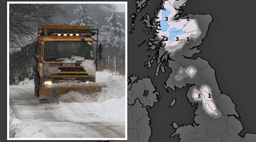
New maps show the areas set to be hit by snow in a matter of days, with one forecaster confirming the UK will see a glimpse of the white stuff before December hits. November 15 appears to be the date as to when the mercury starts to slump, with temperatures struggling to sit above freezing in Scotland and the far north of England. But the chill will cause more widespread snowfall over the preceeding days – with Monday, November 21 earmarked as the date when it’ll push further south, according to an interactive weather model. British Weather Services’ senior meteorologist Jim Dale has exclusively spoken to Express.co.uk detailing exactly what these forecast runs show and whether the nation can expect any snow-related disruption.

Mr Dale, who has previously been cautious when predicting snow showers, has revealed that some of the country is likely to see a dusting at the very least. Maps show snow showers may fall overnight between November 20 and 21 – meaning places that are hit may awake on Monday morning with a delayed commute or school run.
At least 2cm of snow is expected to lay in areas near Newcastle, with this decreasing to 1cm for towns between Manchester and Birmingham. Some very slight signals also point towards rural and higher land in northern Wales being hit by lighter showers.
Forecasts show this dusting will not melt during the day and will hang around until at least November 22. Due to this forecast being nearly a fortnight away, maps do not show this weather front lasting into the end of the month or early December, but Mr Dale has shared some of his own key dates.
He said: “There will be some limited snow in the north west highlands by November 17 in the northern Pennines. It will be just a dusting for now, but a growing threat for Scotland on November 19 and 20. It will be colder for all, though, within that period.”


But, the snow won’t fall nationwide, with most of the country missing the first winter shower of the season. The south east, central and even some northern parts of England will escape the wrath, but people living in these parts of the country will feel colder as thermometers continue to dip at around this time.
Mr Dale added: “It’ll be notably colder in south east but nothing out of the ordinary for the time of year. This will be caused by the movement south of the jet stream – pulling in moderated polar air from Greenland and Iceland way.”
The Met Office’s long range forecasts from November 17 through to November 22 are not so clear cut, but they do allude to colder conditions and a change in temperatures in the final weeks before Christmas.
Looking at November 20 to December 15 it says: “A high-pressure system looks likely to settle to the west or northwest of the UK towards the end of the month, bringing more extended periods of dry and settled weather with lighter winds.


“Rain and stronger winds could still be experienced, especially in the far northwest. Into December, eastern areas could see a return to wetter conditions, with occasional frost and overnight fog, that could be slow to clear. Temperatures trending towards average for the season, perhaps feeling rather cold.”
Looking into the immediate future, forecasters are suggesting a warm blast to hit southern and central parts of the UK this weekend, before the mercury plunges to align with more typical temperatures for the time of year.
Southern and eastern parts of England may be set to see highs of 18C this Sunday, November 13 – but this will be short-lived as chillier conditions move in towards the end of next week.
NetWeather forecasters say it will be this mild phase that will actually encourage colder weather for the second half of the month. In a blog post they say: “High pressure is set to build to the east of Britain, promising much drier, more settled weather for most of the country.
“Winds will remain southerly or south-westerly to begin with, and there is a fair chance of this high pressure bringing mild and dry weather accompanied by bright sunshine to many areas of the UK, which is relatively unusual at this time of year.
“In the long run, however, this shift towards high pressure may eventually result in colder weather developing during the second half of November.”
According to the Met Office Scotland sees the most snow each year, with snow or sleet falling on 38.1 days on average. It says: “Statistically, the snowiest place in the UK is the Cairngorms in Scotland, with 76.2 days of snow or sleet falling on average.
“Cornwall is the least likely to get snow, with an average of only 7.4 days of snow or sleet falling a year.”
Source: Read Full Article