Met Office pinpoints exact day UK is set for snow as temperatures drop
UK weather: Foggy cooler conditions with widespread frost
We use your sign-up to provide content in ways you’ve consented to and to improve our understanding of you. This may include adverts from us and 3rd parties based on our understanding. You can unsubscribe at any time. More info
The Met Office has warned some showers may turn wintry at the start of December as the nation begins to feel the cold. High winds from Poland and Russia could lead to wintry downpours just weeks before the festive period begins. While the UK’s leading forecaster often remains tight-lipped over snow forecasts, its long range outlook for December confirms the chances of snow for the country. Starting from this weekend, people are told to expect occassional showers – with the most frequent being in the east and along southern coasts.

From December 3 to December 12 it says: “On Saturday, rather cloudy with occasional showers, these most frequent in the east and on southern coasts. Most sunshine will be seen in western and northwestern areas.
“At the weekend and into the start of next week, showers are likely, mainly in eastern and southeastern areas and perhaps some more persistent rain to the southwest. These may become wintry, but this risk will be mostly confined to higher ground.
“Towards the end of the period similar conditions are expected to continue with showers present in eastern and southern coastal areas. These also have the potential to become wintry on higher ground.
“Temperatures are expected to be below average, especially in the south at the start of the period where easterly winds will make it feel somewhat colder.”


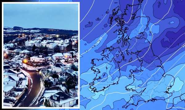
WX Charts’ weather maps for Britain show exactly where snow is set to fall – and pinpoints the times of the day or night it will begin to lay. From 6pm on Saturday, December 3 northern central areas between Newcastle and Manchester look set to get a dusting along with some rural, central parts of Wales.
This is set to increase as the night goes on and the mercury dips even further with wider parts of Scotland blanketed in snow and even parts of the south west, including Plymouth. The maps claim parts of Wales could be set to get up to 4cm by midnight, and up to 6cm in the early hours of Sunday.
While many urban places will see the snow thaw out by the following day, radars show by midday one to 2cm will remain in northern Wales, with some very light snow potentially reaching central western parts of England – although confidence remains low as to whether this will reach the capital.
Throughout the rest of next week, snow appears to remain on higher ground, with some rural areas potentially getting some snow overnight. However, these overnight frosty periods seem to stay throughout the start of the month, indicating a prolonged, colder spell.


The Met Office’s forecast across the latter part of December, including Christmas Day and Boxing Day, is more scant in detail. This is because confidence is far less the further away the prediction time is.
Looking at December 13 to 27, it adds: “Confidence remains low for this period. More settled conditions are expected, with the potential for higher pressure over the UK, leading to drier weather.
“Whilst temperatures may average out close to normal overall, colder conditions are possible at times, with a risk of overnight frost and fog higher than normal.”
Professor Adam Scaife from the Met Office wrote in this blog: “While there are indications in the long-range forecast that we could see some mild weather this winter, we are expecting a colder start. Our medium-range models are starting to indicate that high pressure will begin to dominate our region in December, increasing the potential for cold spells, although we could still see wet and windy weather at times as well as later in the winter.”
He added: “Exact weather conditions will be dictated by just where the high pressure settles over the Atlantic and the UK. While this type of outlook cannot identify day-to-day weather there is relatively good agreement that weather patterns in December will become more settled than we have seen in November.
“High pressure prevents mild, moist air from flowing to the UK from the Atlantic Ocean increasing the potential for lower temperatures, with some threat of snow and ice mainly in northern areas and a reduction in the chance of early winter storms compared to normal.
Prof Scaife did say that long-range forecasts are able to give sector bosses a heads up for adverse weather on the horizon, but is less useful for many who want a definitive answer as to whether the nation will have a white Christmas.
He added: “The long-range outlook cannot identify the weather on a given day or even week, so it is not very useful if you want to know if we will see snow on Christmas Day. - Nevertheless, certain industries and sectors of society do find this type of information helpful. Especially those who can benefit from insight about the coming season, such as whether it is more likely to be wetter or drier, warmer or colder, windier or calmer than average.”
Source: Read Full Article