St. Louis hit with "catastrophic" rainfall, flash flooding prompts rescues
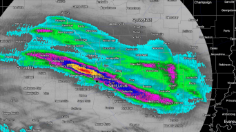
Total rainfall accumulation from St. Louis' radar, via RadarScope. Blue hues correspond to 8 inches of rainfall.
Record rainfall caused flash flooding across St. Louis metropolitan area, prompting multiple rescues and closing several roads.
The latest: City fire officials reported at least one death after a vehicle was submerged in water around 10:30 a.m. Tuesday, according to the St. Louis Post-Dispatch.
- Firefighters responded to several homes across the city with substantial flooding and stranded vehicles.
Why it matters: The rising waters and numerous rescues led the National Weather Service to issue its most dire flood warning, known as a "flash flood emergency."
- Extraordinary rainfall rates of up to 3 inches per hour in some areas caused the all-time 24-hour rainfall record to be broken in under 8 hours.
- Due to the high levels of rain, and water rescues, the National Weather Service issued its most dire flood warning, known as a "flash flood emergency."
By the numbers: The National Weather Service office in St. Louis said Tuesday that the area's daily rainfall record was shattered with more than 8.5 inches of rain observed in the St. Louis area.
- Tuesday's rainfall broke the old daily record of 6.85 inches set in August 1915, which was caused by remnants of the Galveston, Texas, hurricane.
- The city received 7.68 inches of rain in just six hours and about 25% of its yearly rainfall amount in just 12 hours.
- "Catastrophic life-threatening flash flooding across parts of metro St. Louis. will be possible," a National Weather Service bulletin read.
Our thought bubble via Axios' Andrew Freedman: Historic downpours and related flash floods are becoming more severe and more common as the climate warms due to the burning of fossil fuels, since warmer air can hold more moisture.
No injuries were reported as of 6 a.m. Tuesday, though firefighters responded to several homes across the city with substantial flooding, according to the St. Louis Post-Dispatch.
The big picture: Thunderstorms and heavy rainfall were expected to continue mid-morning, which will be followed by hot temperatures and high humidity until 7 p.m., according to the National Weather Service.
- Heat index values are expected to hit 108 degrees Fahrenheit in parts of Missouri.
Editor's note: This story has been updated with new details.
Source: Read Full Article


