New weather maps show exact areas set to be hit with more snow chaos
UK Weather: Met Office issue yellow warning
We use your sign-up to provide content in ways you’ve consented to and to improve our understanding of you. This may include adverts from us and 3rd parties based on our understanding. You can unsubscribe at any time. More info
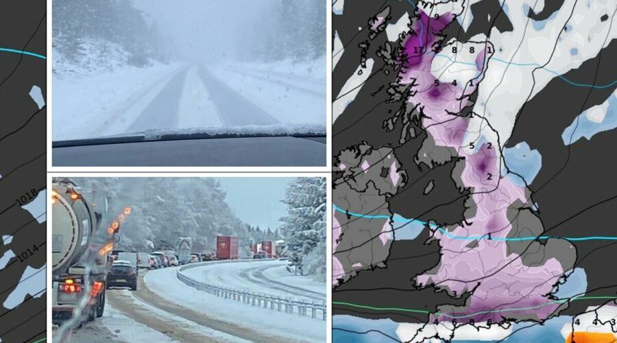
Snow has brought the UK to its knees with scores of drivers stranded, as a major incident has been declared on a three-mile stretch of the M25 alone. Snow-logged schools have shut their gates and aircrafts have been grounded at some of the country’s busiest airports. The wintry showers have not been confined to the north or Scotland, with London and parts of central eastern areas seeing a substantial amount fall overnight. While many children will be rejoicing at the chances of a snow day – others will be looking to find out how long this chaos is set to go on for.

Jim Dale, senior meteorologist from British Weather Services, has offered some hope to those who are desperate for temperatures to increase and the snow to thaw out. He said the picture should start improving by this weekend for many.
He told Express.co.uk: “It’s going to be less painful but still freezing. Emphasis shifts back to Scotland for snow events. It is slowly becoming less cold with time from the south west by the weekend. It will only be the odd well-scattered snow shower, no repeats of London and co just yet.”
The mercury may settle to between 7C and 12C in southern areas by Sunday, he predicted. Cornwall may be set to scoop the mildest temperature – but sub-zero conditions are unlikely to improve for a time in Scotland and the north east.
Weather maps tell a more crushing tale. WX Charts, the interactive weather model, shows the south could be set for more of a dusting on Wednesday. Up to 2cm of snow could fall across the southern coast of England on Tuesday night, with more travel woes potentially striking on Wednesday morning.


If this model is anything to go by, much of Britain will still be under a blanket of snow by Thursday at least. The Met Office has issued a series of yellow weather warnings for snow and ice covering south east England, north east and Scotland. All of these expire before Friday, with early indications that the weather may settle by then.
But the only relief the weather maps show is a huge rain shower pushing across the east of the country, off the Atlantic, by next Monday – with no sign of any more snow during this brief interlude.
From next week, central and southern parts of the UK will begin to thaw out, the maps show – but northern England, Scotland and a large part of Northern Ireland will still be carpeted in snowy conditions up until Christmas Day. This brings huge potential for a festive winter wonderland for many people.
Temperature maps show an almost north-south divide next Monday, with the south recovering from the sub-zero depths during the day and sitting at 9C. But this appears to be shortlived as the mercury drops back down to 0C by Wednesday. In the south, thermometers will drop down to -1C on Boxing Day and down to -4C in the north east and Scotland.


A Level 3 cold weather health alert has been extended into this week, with its expiry date set to this Friday. While this also supports a settling of conditions at the end of the week, the country may have to endure more snow beforehand.
It says: “Cold weather is now established across the country. Very cold nights are expected over the weekend into the early part of next week, with widespread moderate, locally severe, frosts, and some freezing fog patches in places.
“Daytime temperatures will remain low, with some places struggling to rise above freezing, more especially where any fog patches linger. Wintry showers will continue to affect some coasts, pushing into some inland areas at times, bringing a risk of icy patches and slight accumulations of snow.
“From around mid-week next week, Atlantic weather systems may try to push north or northeast into the south or southwest of the UK, which could bring some stronger winds and a risk of snow. However, this is currently low confidence as there is a good deal of uncertainty regarding the proximity to the UK of any such weather systems. A further update to this alert is likely.”
Looking ahead to the rest of the month into January, there is no promise of an improvement in conditions. The Met Office’s long range forecast from December 16 to 25 says: “Sleet and snow showers are likely to continue across the north and east, and perhaps into the southwest of the UK at the beginning of the period, although these should be mainly confined to coastal regions.
“Elsewhere it should be mostly dry, clear and often sunny further inland with light to moderate winds. Generally feeling cold to very cold, with widespread frosts overnight and a chance of freezing fog in places.
“A more unsettled regime is likely to develop later on in the period, bringing spells of rain and possibly snow into many parts of the UK, especially the south and the west with strong winds in places. Temperatures are likely to turn less cold through the remainder of this period.”
Into January it adds: “General themes remain uncertain for the rest of the period. Conditions may be widely changeable, with some spells of rain, and at times snow. Colder and more settled conditions with occasional wintry showers could continue, particularly in the north, with the south possibly seeing more unsettled conditions. Temperatures staying colder than average towards the end of December and start of January, although perhaps less cold in the south.”
Source: Read Full Article